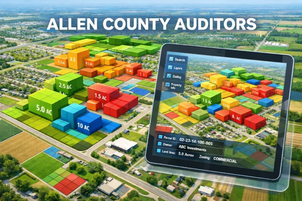
If you’ve ever opened the Allen County GIS Parcel Map and immediately felt like you clicked into a government-designed escape room, you’re not imagining it. GIS sounds technical, the map looks busy, and nothing explains itself. Yet this tool pulls real data from the Allen County Auditor and County Engineer, making it one of the most important sources for understanding property in Allen County.
Boundaries, parcel numbers, zoning layers, land size, and links to tax data all live here. This guide exists to translate the map into plain English. You’ll learn, what the Allen County GIS Parcel Map actually shows, what it does not show, how to find your property fast, and how to use the data without making expensive assumptions. This guide is based on how the Allen County GIS system actually works in practice, not just what the interface shows
Whether you’re doing an Allen County property search, reviewing parcel boundaries, or using a GIS property lookup, this map simplifies how property data is accessed
What the Allen County GIS Parcel Map Actually Shows (And What It Doesn’t)
The Allen County GIS Parcel Map is a digital property reference system, not a legal document and not a survey. It visually displays parcel boundaries across the county and connects each parcel to public data pulled from county offices. When you click a property, you’ll typically see parcel ID, owner name, acreage, zoning classification, and links to Auditor records. This is why people call it a GIS property map. It helps you understand how land is organized, not settle disputes.
What it does not show is equally important. It does not replace a professional land survey, it does not guarantee exact boundary placement, and it does not calculate your taxes. Think of the county GIS system as a reliable overview tool, not a final authority. The data shown in the GIS system is typically maintained by the Allen County Auditor’s Office and supported by mapping data from the County Engineer.
Example: A homeowner checking whether their fence might cross into a neighbor’s lot can use the GIS map to get a general idea, but must still order a survey before building or arguing.
I Just Want to Find My Property on the Map
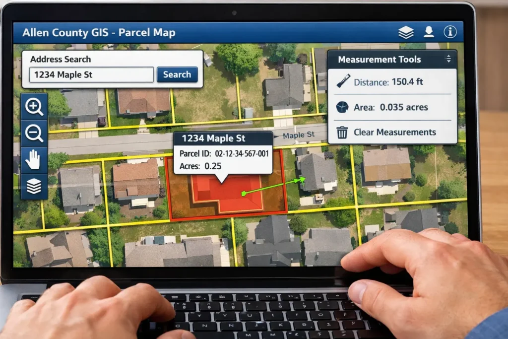
When the GIS map opens, panic usually follows because everything is zoomed out and layered. Ignore the chaos. Start with the search bar. The Allen County GIS allows property lookup by address, parcel number, or owner name. Address search is the fastest for most people. Enter the street address, select the correct result, and the map will zoom directly to the parcel.
For most users, this tool works just like an Allen County property search, but with a visual map instead of a simple list. Parcel search is useful if you already have the parcel ID from a tax bill or Auditor page. Owner name search works but can return multiple results, especially with common names. Once the parcel loads, it highlights the property and opens an information panel. Imagine the map like a Google Map with extra buttons. Zoom, click, read. That’s it.
What Is a Parcel Number and Where Do I Find It?
A parcel number, also called a parcel ID, is a unique identifier assigned to each property in Allen County. It’s how the county tracks land across systems. You’ll find this number on property tax bills, deeds, Auditor property records, and sometimes mortgage paperwork. On the GIS map, the parcel number appears in the property information panel once you select a parcel.
To use it, copy the number exactly and paste it into the GIS search bar. This bypasses confusion when addresses change or properties are split. Parcel number lookup is especially helpful for vacant land or rural properties where addresses are unclear. Most people ignore this number simply because it’s never clearly explained. Once you have it, property research becomes dramatically faster.
I Don’t Understand Property Boundaries on the Map
Those thin lines outlining properties are parcel boundaries. They show how the county believes parcels are divided for record-keeping purposes. They are not zoning lines, and they are not guaranteed to be survey-accurate. Zoning boundaries, when enabled, appear as broader overlays and often do not align perfectly with parcel edges.
This distinction matters. Parcel boundaries define ownership references. Zoning lines define how land can be used. Confusing the two leads to bad decisions. Also important is the disclaimer: GIS boundary lines are approximate. They are derived from recorded documents, not field measurements.
Never treat a GIS boundary as a legal line in a dispute. If you need exact legal boundaries, only a licensed land survey recorded with the county should be relied on.
How Accurate Is the Allen County GIS Map?
The Allen County GIS pulls data primarily from the Auditor’s Office and County Engineer. Ownership, parcel shapes, and measurements are updated periodically, but not in real time. Accuracy is high for general reference but limited for legal precision. Changes like lot splits, new surveys, or recent deeds may lag behind.
This is where trust level matters. The parcel map accuracy is good enough for planning, research, and understanding layout. It is not accurate enough to replace a licensed surveyor. Even though the map is reliable for general use, small shifts in boundary lines can exist due to how GIS data is digitized
Pro Tip: If a boundary decision could cost you money or trigger a dispute, stop using GIS and call a surveyor or the county office. GIS is a preview, not proof.
I Want Zoning and Land Use Information
Zoning information is one of the most valuable GIS features. By turning on zoning or land use layers, you can see how Allen County classifies land as residential, commercial, agricultural, or mixed-use. Clicking a parcel usually displays a zoning code, which can then be looked up for permitted uses.
The GIS map gives visibility, not permission. For confirmation, you must contact the county zoning office or local municipality. Still, this map prevents costly surprises by showing zoning conflicts early.Many property issues start because zoning was never verified before purchase
Can I See Tax Information From the GIS Map?
Yes, but with limits. The GIS map often displays assessed value and includes links to the Allen County Treasurer or Auditor pages. It does not calculate taxes or show payment status. Think of it as tax context, not tax control.
For actual balances, due dates, or delinquency status, you must click through to the Treasurer’s site. This separation exists for a reason. GIS visualizes land. The Treasurer manages money. The GIS map acts as a bridge that connects you to broader Allen County property records available through official county systems
Mixing the two leads to confusion and panic that could’ve been avoided. For official tax records, always verify details through the Allen County Treasurer or Auditor website
The Map Tools Are Confusing
GIS tools look intimidating but they’re basic once you slow down. Zoom and pan work like any map. The layer tool turns information on and off. The measure tool lets you calculate distance or acreage directly on the map. This is useful for rough estimates, not construction planning. If the map becomes difficult to navigate, use the reset view button. It recenters everything and restores sanity.
Example: Measuring the distance from a property line to a road can help buyers understand access before visiting in person.
Common Mistakes When Using the Allen County GIS Map
- Assuming boundaries are exact
- Ignoring zoning layers
- Not verifying tax data from official sources
- Using GIS for legal disputes
- Not checking parcel history
Can I Print or Share My Parcel Map?
Yes, and you should do it properly. The Allen County GIS offers print and export options. PDF format is best for clarity and sharing with agents or offices. Image formats work but lose scale accuracy. Before exporting, turn off unnecessary layers, zoom tightly to the parcel, and include labels.
Clean maps communicate better than screenshots. This matters when dealing with officials, buyers, or neighbors. Official-looking maps are especially helpful when communicating with real estate agents, surveyors, or county offices.
Pro Tip: Always include parcel number and north arrow when printing. It prevents confusion later.
Is This Map Useful for Buying, Selling, or Disputes?
Absolutely, with boundaries. Buyers use GIS to understand lot size, neighboring parcels, access points, and land shape. Sellers use it to visually explain property layout. In disputes, GIS serves as a reference tool, not evidence.
For legal ownership, surveys and recorded deeds still rule. GIS helps you understand a property, but final decisions should always rely on legal documents, surveys, and official county records. Knowing when to stop relying on the map is part of using it correctly.
Allen County GIS Parcel Map Quick Reference
| Information You Need | Where to Find It |
|---|---|
| Property address / parcel number | GIS Parcel Map search bar |
| Owner name | GIS Parcel Map / Auditor site |
| Parcel boundaries | GIS Parcel Map |
| Zoning / Land use | GIS layers / Zoning office |
| Lot size / acreage | GIS measurement tools |
| Assessed value | GIS parcel details / Auditor site |
| Tax info link | GIS parcel details / Treasurer site |
| Legal survey reference | County Engineer / Licensed surveyor |
Quick Allen County GIS Parcel Map Checklist
Follow this quick checklist to use the GIS map efficiently
- Identify your property address or parcel number
- Open the Allen County GIS Parcel Map online
- Search by address, parcel number, or owner name
- Review parcel boundaries and layers
- Turn on zoning or land use layers if needed
- Note assessed value or link to tax info
- Measure distances or lot size using map tools
- Save, print, or export PDF of the map
- Contact Auditor or County Engineer if data seems incorrect
Understanding how to use the Allen County GIS Parcel Map correctly can save time, prevent costly mistakes, and give you a clear picture of any property before making decisions.
FAQs
Is the Allen County GIS Parcel Map free to use?
Yes. The Allen County GIS parcel map is a public tool and can be accessed by anyone without cost or registration.
Can I use the GIS map to confirm my exact property boundaries?
No. The GIS map shows approximate parcel boundaries only. Legal boundaries require a licensed land survey.
How often is Allen County GIS data updated?
Updates come from the Auditor and County Engineer. Changes like new deeds or parcel splits may take time to appear.
Can I search the GIS map using just my address?
Yes. Address search is the easiest method for most homeowners and works for the majority of residential properties.
Does the GIS parcel map show property tax amounts?
It may show assessed values and links, but actual tax bills and payment status are handled by the Allen County Treasurer.
Is the GIS map reliable for buying or selling property?
It is useful for understanding parcel layout and surroundings, but it should support decisions, not replace surveys or title research.