Searching for property owner and parcel details online in Allen County usually starts when something important is on the line. Most users expect one official search page to show everything. Instead, they land inside multiple county systems that each show different pieces of the puzzle. This often leads to confusion, especially for first-time users trying to find accurate property information quickly.
The data is publicly available, but knowing how to access it correctly is what makes the difference. The challenge is understanding where to start and how each system connects. This guide explains the full workflow so you can find verified owner and parcel data without guessing or relying on risky third-party sites.
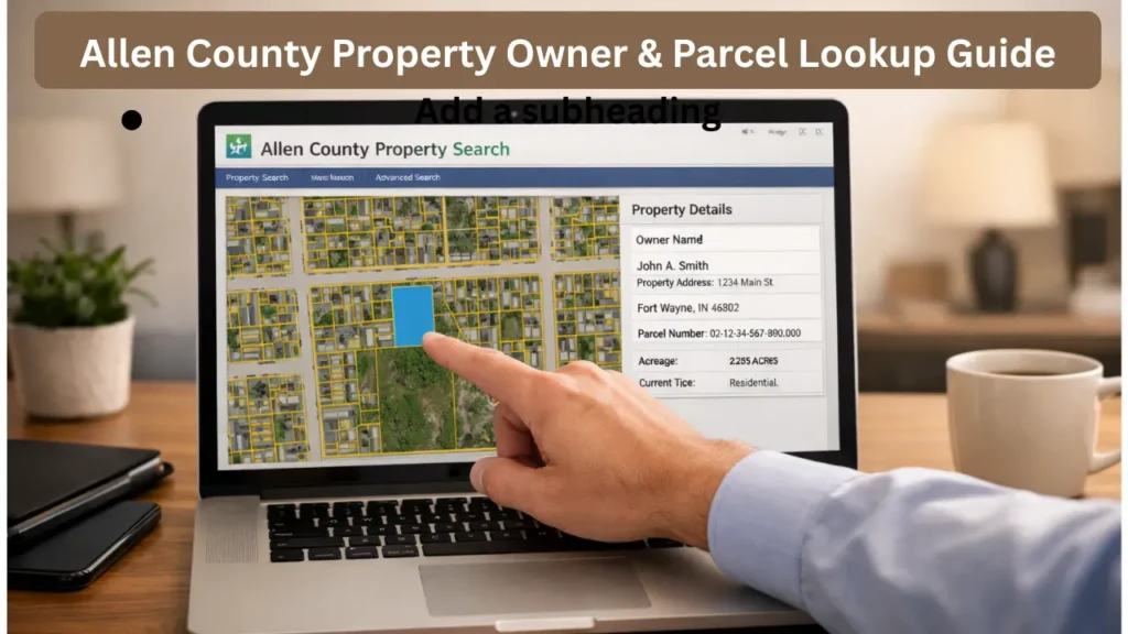
Allen County property data is mainly split across the Auditor, Recorder, and GIS mapping systems. The Auditor handles tax data, parcel numbers, and property characteristics. The Recorder handles legal ownership through deed documents. The GIS system shows parcel boundaries and location maps. Most search mistakes happen when users rely on only one system instead of using all three together. Learning how these systems connect is the key to fast and accurate property research. If you’ve ever struggled to find the correct property details online, this step-by-step guide will make the process much easier.
Who This Guide Is For:
- Researchers analyzing land data
- Property buyers verifying ownership
- Real estate investors researching tax data
- Homeowners checking property records
Where to Start Searching Property Records in Allen County
Most users should start with the Allen County Auditor property search because it is the easiest place to find parcel numbers, tax values, and basic property details. The Auditor system acts like the central index for property research. Once you have the parcel number or property summary, you can move to the Recorder system to verify legal ownership using deed records. If you need land boundary visuals, you then move to the GIS parcel map viewer. Using this order prevents confusion and reduces duplicate searching.
Quick Step Flow:
- Search property in Auditor system
- Copy the parcel number
- Verify ownership in Recorder records
- Use GIS map for boundary confirmation
The Auditor system is best for tax history, property characteristics, and sales summaries. The Recorder system is best for proving legal ownership and transfer history. The GIS system is best for visual parcel boundaries and land layout. Using these systems together gives you a complete property profile instead of partial information.
When Address Search Does Not Work
Address searches often fail because county databases use strict formatting rules. Even small differences like Street vs St or North vs N can break search results. Rural properties sometimes register under parcel-based indexing instead of standard addresses. This is why parcel number searches usually work better than address searches.
If address search fails, try searching by owner name or parcel number. Owner name search helps when you know who owns the property but not the stored address format. Parcel number search works best when you want exact matches without formatting errors.
Pro Tip: If name search returns multiple results, filter by city, property type, or sale year to narrow results.
Understanding Parcel Numbers and Legal Descriptions
Parcel numbers are unique ID numbers assigned to each land parcel for tax and record tracking. These numbers often reflect township, section, and lot identifiers used internally by the county. While they look random, they are designed for database accuracy and long-term record tracking.
Legal descriptions describe the land itself rather than the mailing address. These appear on deeds and legal documents and define property boundaries using subdivision lots or metes-and-bounds measurements. Legal descriptions are important for ownership transfers, title research, and legal disputes.
Example: A title company uses legal description data to verify exact land boundaries during a property closing process.
How to Verify Who Really Owns a Property
Many users assume the name listed in the tax record is always the legal owner. Sometimes it is. Sometimes it is just the tax mailing contact or property manager. The Recorder deed database is the official legal ownership source because it shows the most recent recorded transfer.
To confirm ownership, search the Recorder database and locate the newest deed document. The deed shows the grantor (seller) and grantee (buyer) and confirms the legal transfer date. Following multiple deeds creates a chain of title showing ownership history over time.
Understanding Property Record Data Fields
Property record pages contain large amounts of technical data, but most users only need key sections. Property characteristics show building size, lot size, and structure details. Tax sections show assessed value and payment history. Sales sections show past transfer prices and dates.
Assessed value is used for tax calculations and may not match market value. Market value reflects what buyers are currently willing to pay. Understanding this difference prevents confusion when comparing tax records with real estate listings.
Quick Tip: Compare assessed value trends over multiple years instead of judging based on one year.
Using Property Data for Buying, Selling, or Research
Property records help buyers verify property history, help investors evaluate tax trends, and help researchers study ownership patterns. Sales history helps show price trends. Zoning data explains how land can legally be used. Tax history helps predict long-term ownership costs.
Using all three together helps buyers avoid risky purchases and helps investors make data-driven decisions.
Example: An investor checks zoning plus tax history before buying a rental property to estimate long-term cost
Avoiding Third-Party Property Search Scams
Many third-party property sites charge fees for data counties provide for free. Some sites also display outdated data or incomplete ownership history. Official county property sites are always the safest data source.
Official sites may look outdated but provide legally verified information. Third-party sites should only be used for quick summaries, not legal or financial decisions.
Example: A buyer pays a third-party site for ownership info but later finds updated ownership on the Recorder site for free.
How Current Are Allen County Property Records
Auditor and GIS systems usually update frequently, but deed recording updates depend on document processing time. If a sale happened recently, the deed record may appear before tax records update. If researching a very recent transfer, check Recorder records first, then verify tax updates later.
Helpful Insight: Recent ownership confirmation should always start with deed records.
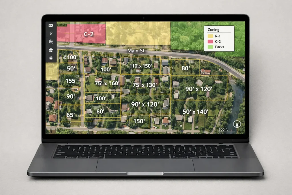
Using GIS Maps to Confirm Parcel Boundaries
GIS parcel maps show land boundaries, lot dimensions, and neighboring parcel layout. These maps help confirm land location visually. GIS maps are especially helpful for land purchases and boundary verification. GIS tools may include zoning layers, aerial imagery, and flood zone overlays. These are helpful for planning and land research.
Example: A buyer checks GIS to confirm property backs up to a commercial zoning area before buying.
Simple Property Research Checklist
- Start with Auditor property search
- Save parcel number immediately
- Verify ownership using Recorder deed records
- Check sales history for transfer timeline
- Use GIS map to confirm parcel boundaries
- Cross-check recent transfers through Recorder
- Avoid third-party paid lookup websites
Where Each Type of Property Data Comes From
Here’s a quick breakdown of where each type of property data comes from:
| Data Type | Main Office | Why It Matters |
|---|---|---|
| Parcel Number | Auditor | Core property identifier |
| Tax History | Auditor | Shows tax trends and cost history |
| Legal Ownership | Recorder | Confirms real legal owner |
| Deed Transfers | Recorder | Shows ownership timeline |
| Parcel Boundaries | GIS | Shows land shape and location |
| Zoning Overlay | GIS | Shows allowed land use |
Common Search Mistakes in Allen County Property Research
Avoid these frequent errors when searching property records:
- Searching only by address: Minor differences like “Street” vs “St” or “North” vs “N” can break results. Parcel number searches are more reliable.
- Trusting tax owner name blindly: Tax records may show a mailing contact, trust, or property manager. Always verify ownership in the Recorder deed database.
- Ignoring deed recording dates: Legal ownership updates when the deed is recorded. Always check the newest deed to avoid outdated assumptions.
- Not saving the parcel number early: The parcel number is the key identifier across Auditor, Recorder, and GIS systems. Saving it prevents duplicate or mismatched searches.
Conclusion
Finding owner and parcel details online in Allen County becomes straightforward once you follow the right system workflow. Start with the Auditor to gather parcel numbers, tax data, and property characteristics. Then move to the Recorder to confirm legal ownership and review deed transfers. Use the GIS system last to visualize parcel boundaries and understand land layout.
Avoid common mistakes like relying solely on addresses, trusting tax records without verification, ignoring deed recording dates, or failing to save parcel numbers early. Following this structured approach reduces errors, prevents outdated assumptions, and ensures you have accurate, verified property information.
Taking a few extra minutes to verify records across all systems can help you avoid costly mistakes and ensure accurate property information
FAQs
1. Are Allen County property records public?
Yes, most property tax, parcel, and deed records are public unless legally sealed.
2. Which office confirms legal ownership?
The Recorder Office confirms ownership using deed records.
3. What is the fastest way to search property across systems?
Parcel number search is the fastest and most accurate method.
4. Why does tax owner name sometimes differ from deed owner?
Tax systems can lag behind legal deed recording updates.
5. How often are records updated?
Auditor and GIS update frequently. Deed records update after document recording.
6. Should I trust third-party property lookup sites?
Use them only for quick summaries, never for legal verification.